I will georeference, digitize, and design layout maps using arcgis

A
abdulwahid661
A
abdulwahid661
Wahid

About this gig

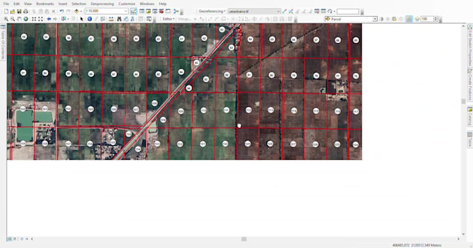
If you are looking for GIS Mapping Expert and Remote Sensing tasks, then this gig is for you.

I am a GIS Professional and Cartographer having a Master's Degree in Remote Sensing and GIS . I have 5+ years of experience in the GIS and Remot sensing and I will solve/explain real-world phenomena with GIS Maps and Data Visualization. I can also help you with your research works.

The maps will be professional level maps including Land use map, street maps, road maps, simple digitized maps, utility services maps and other maps as per demand.


Services:

  1. Georeferenceing
  2. Digitization
  3. I will make study area map for your research.
  4. Map for your project ,thesis etc.
  5. i will write a literature review for your research.
  6. Research and conduct tests on new researching tools
  7. Digitizing Point, Lines, and Polygon in Vector format.
  8. AutoCAD File to Shape file
  9. Shape file, Feature Class, Geodatabase, kml , etc.
  10. Standardization of attributes
  11. Google Earth Mapping
  12. Base Map
  13. Coordinate System
  14. Layout Mapping 

Get to know Wahid

Wahid

GIS Specialist

2.2(2)
  • FromPakistan
  • Member sinceAug 2022
  • Last delivery1 year
  • Languages

    Urdu, English, Hindi
Hi Welcome to my Profile. Myself Abdul Wahid with 6 years of experience in GIS and remote sensing, I provide expert services including georeferencing, digitizing, and custom map design using ArcGIS and QGIS. I specialize in GIS and Remote sensing analysis , creating interactive maps, scraping geospatial data, automating processes, and converting GIS data into any format. My focus is on delivering high-quality, tailored solutions . Let's collaborate to enhance your project with precise GIS solutions!

My Portfolio