Browse categories
Explore
Fiverr Pro
English
$
USD

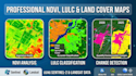


Expert GIS & Remote Sensing Solutions
As a Survey & GIS Engineer (Mansoura University), I transform satellite data into actionable insights for agricultural and environmental projects.
What I offer:
Software Expertise: I use ArcGIS Pro, QGIS, and Google Earth Engine for 100% accuracy.
Why Choose Me?
Requirement: Please provide the Area of Interest (AOI) & time range.
GIS Specialist and Survey Engineer
Languages
What satellite data sources do you use
I primarily use Sentinel-2 (10m resolution) and Landsat 8/9 (30m) for high-quality free data. If your project requires high-resolution commercial imagery (like Maxar or Planet), I can process it if you provide the data.
What file formats will I receive
You will receive professional map layouts in PDF, JPEG, and PNG. Additionally, I provide the source geospatial data in Shapefile (.shp) or GeoTIFF formats to ensure compatibility with your GIS software.
Can you perform analysis for large-scale regions
Yes, using Google Earth Engine and automated workflows in ArcGIS/QGIS, I can efficiently process large-scale regional or national datasets while maintaining engineering precision.


