Browse categories
Explore
Fiverr Pro
English
$
USD

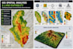
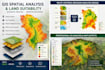

Need to identify suitable locations or understand spatial patterns using GIS?
I will perform professional GIS spatial analysis to turn your spatial data into clear, decision-ready results.
Services include:
Spatial analysis and proximity analysis
Land suitability analysis
Multi-Criteria Decision Analysis (MCDA)
Weighted overlay analysis
DEM, slope, and terrain analysis
Raster reclassification and overlay
Site suitability mapping
Spatial data preparation and visualization
I can work with vector and raster datasets such as shapefiles, GeoJSON, GeoTIFF, DEMs, coordinates, and other relevant spatial data.
Depending on your package, I can combine multiple criteria, prepare the datasets, perform the analysis, and deliver professional analytical maps and outputs.
Tools: QGIS and ArcGIS workflows.
Please contact me before ordering if your project requires a specific methodology, weighting system, CRS, dataset, or analysis workflow.
GIS Geospatial Analyst Mapping Spatial Analysis
Languages
What types of spatial analysis can you perform?
I can perform proximity and buffer analysis, spatial overlay, raster analysis, terrain analysis, site suitability analysis, and other GIS-based spatial analyses depending on your data and requirements.
Can you perform land suitability analysis?
Yes. I can integrate multiple spatial criteria and produce suitability results using GIS-based methods such as reclassification, MCDA, and weighted overlay.
Do I need to provide all the datasets?
Ideally, yes. You can provide your existing spatial data, such as shapefiles, GeoJSON, GeoTIFF, DEMs, or coordinates. If you are unsure about the required datasets, contact me before ordering.
Can you use my own criteria and weights?
Yes. If you have predefined criteria, weights, or a specific methodology, provide them with your order. I can apply them as part of the agreed analysis workflow.
Can you help determine suitable locations for a project?
Yes. I can perform GIS-based suitability analysis using the spatial criteria and methodology provided. The final suitability result is a GIS analytical output and should be interpreted according to the project's requirements.


