Browse categories
Explore
Fiverr Pro
English
$
USD



Live Demo:
https://wayanad-landslide-emergency-response.duckdns.org
Build a powerful and modern WebGIS application for disaster management, environmental monitoring, infrastructure planning, emergency response, spatial analysis, and interactive mapping.
I specialize in developing custom GIS web applications using GeoServer, OpenLayers, QGIS, PostGIS, HTML, CSS, JavaScript, and AWS deployment. I can transform your GIS data into an interactive spatial dashboard with professional UI/UX and real-time map interaction.
Services include:
Interactive WebGIS Dashboards
GeoServer Setup & Configuration
OpenLayers Web Mapping
WMS/WFS Integration
API integration
ETL,automation Pipeline
Spatial Analysis Visualization
Disaster & Emergency Mapping
Routing & Accessibility Mapping
Custom GIS Layer Styling (SLD)
AWS Deployment & SSL Setup
PostGIS Integration
Supported formats:
Shapefile, GeoJSON, GeoPackage, Raster TIFF, PostGIS, WMS/WFS services, and more.
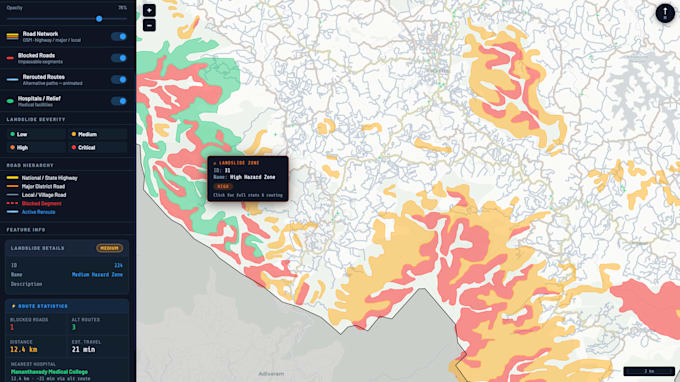
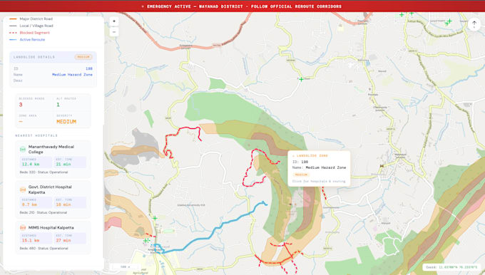
I recently developed a complete Landslide Emergency Response WebGIS platform featuring landslide severity mapping, hospital accessibility analysis, blocked road detection, rerouting visualization, and interactive decision-support tools.
GIS analyst and specialist
Languages
What type of WebGIS applications can you build?
I can build disaster management dashboards, environmental monitoring systems, emergency response platforms, infrastructure mapping portals, routing systems, spatial analytics dashboards, and custom interactive GIS web applications.
Which technologies do you use?
I mainly use GeoServer, OpenLayers, QGIS, PostGIS, HTML, CSS, JavaScript, AWS EC2, Nginx, and SLD styling for GIS web development.
Can you deploy the WebGIS application online?
Yes. I can deploy your project on AWS or your preferred cloud server with SSL/HTTPS configuration and domain setup.
What GIS data formats do you support?
I support Shapefiles, GeoJSON, GeoPackage, Raster TIFFs, CSV spatial data, PostGIS databases, WMS/WFS services, and many other GIS formats.
Will the application work on mobile devices?
Yes. I can create responsive WebGIS dashboards compatible with desktop, tablet, and mobile devices.