Browse categories
Explore
Fiverr Pro
English
$
USD

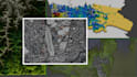
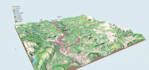
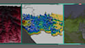
I will transform your geospatial data into high-quality 3D models and realistic visualizations for research, presentations, and planning. Using DEM, satellite imagery, LiDAR, shapefiles, and contour data, I create accurate terrain, landscapes, and city models tailored to your needs. My services include 3D terrain modeling, landscape visualization, textured surfaces, and integration of rivers, lakes, and land cover layers. In addition to static renders, I also provide web-interactive 3D models that can be viewed and explored online, allowing smooth navigation and dynamic presentations. Whether you need a detailed research visualization, an urban planning model, or a 3D map for simulations and AR/VR, I ensure accuracy, realism, and professional quality. With expertise in Blender, QGIS, and remote sensing workflows, I can deliver precise 3D scenes, ready-to-use models (OBJ, FBX, STL, GLTF), and high-resolution renders. I also offer optional animation fly-throughs and presentation slides for academic, professional, or commercial use.
GIS analyst and specialist
Languages


