Browse categories
Explore
Fiverr Pro
English
$
USD


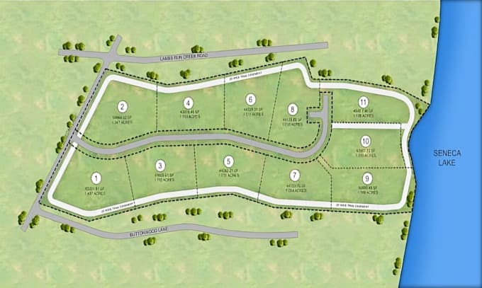
Professional Lot & Land Subdivision Plans in AutoCAD
Need a clear, submission-ready subdivision plan? I design lot subdivision, land subdivision plan and site plan in AutoCAD for real estate, land development, and plat map needs.
Services I offer
Why work with me
Ideal for land developers, agents, surveyors, and engineers who need a professional lot layout, subdivision plan, or site plan from survey, GIS, or sketch.
Before ordering, please send your base map/survey, target lot count or program, and any local requirements so I can confirm scope and pricing.
Please inform the freelancer of any preferences or concerns regarding the use of AI tools in the completion and/or delivery of your order.
Architectural Designer and 3D Character Artist
Languages
What do you need to start my lot subdivision or land subdivision plan?
Please send your latest survey, plat, or GIS map (PDF/DWG), target lot count or program, and any local requirements (setbacks, frontage, access). I’ll use this to create your subdivision plan and site plan accurately.
Do you design subdivision plans suitable for land development?
Yes. I create lot subdivision, land subdivision plan and 2D site plan layouts ready for development concepts, real estate maps, and permit discussions. Always share your local checklist so I can align the design.
What file formats will I receive for my subdivision plan?
You will get layered AutoCAD (DWG) files plus high-resolution PDFs for printing or submission. If you need additional formats (e.g., DXF), message me before ordering your lot subdivision or plat map.
Can you create plat maps or parcel maps for real estate use?
Yes. I design plat maps, parcel maps, and site plans for real estate marketing and land development. Share your boundary data and any branding or layout preferences for your real estate map.
Do you work from Google Maps, county GIS, or survey data?
Yes. I can base your subdivision plan and site plan on Google Maps, county GIS, or a recorded survey. For official permits, using a recent survey or recorded plat is recommended for accurate boundaries.