Browse categories
English
$
USD
Connect to your AI
HELLO AND WELCOME!!
Are you looking for a clear, professional wayfinding map to guide visitors through your museum or zoo? Look no further!
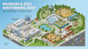
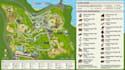
I design custom 3D isometric museum maps and zoo wayfinding guides for museums, zoos, wildlife parks, cultural centers, and visitor attractions. I transform site plans, aerial views, floor plans, or sketches into clear visual navigation tools.
What I Can Map Out For You:
Why Choose Me?
Ready to turn your museum or zoo layout into a clear, engaging visitor map? Message me before ordering with your site plan or reference, and lets discuss the details and create a wayfinding guide built for your visitors.
Please inform the freelancer of any preferences or concerns regarding the use of AI tools in the completion and/or delivery of your order.
Map Designer and Cartographic Illustrator
Languages
Can you include exhibits and animal habitats?
Yes, I can include galleries, exhibits, animal habitats, viewing areas, buildings, pathways, landmarks, and visitor facilities.
Can you create a map from an existing site plan?
Yes, I can transform your site plan, aerial image, floor plan, sketch, or existing layout into an isometric visitor map.
What file formats will I receive?
You can receive high-resolution PNG/JPG, print-ready PDF, and editable AI/source files depending on your package.


