Browse categories
Explore
Fiverr Pro
English
$
USD
3D Modeling Pro for Google Earth, Drone Data and 3D printable cities
Level 2
Has met high performance criteria and has a proven track record for meeting client expectations.
Highly Responsive
Known for exceptionally quick replies
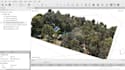
Welcome! I'm Aliyu, a dedicated photogrammetry specialist with over 4 years of experience transforming drone and UAV imagery into precise, actionable data for engineering, construction planning and development projects. Using licensed Pix4D, I deliver survey-grade accuracy.
Key Deliverables:
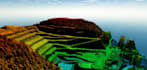
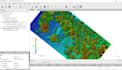
DTM / DSM & 3D Models
Cut/Fill Volume Calculations
Contour Maps & Orthomosaics
3D Point Clouds & Project Files
I provide trusted data for terrain analysis, earthwork planning, and design. My 4+ years of expertise ensures reliable, fast results for professionals.
Message me before ordering to discuss your project needs!