UAV Mapping Processing Services
My processing services specialize in high-precision UAV (drone) data analysis, offering three key mapping solutions:
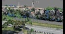
- RGB Image Mapping: Captures high-resolution visual imagery for detailed orthomosaics, 3D models, and topographic mapping. Ideal for surveying, construction monitoring, and site documentation.
- Thermal Mapping: Utilizes infrared data to detect heat patterns, enabling applications in building inspections and solar panel assessments.
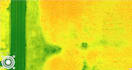
- Multispectral Mapping: Analyzes plant health, soil conditions, and environmental factors using multiple spectral bands. Commonly used in agriculture, forestry, and environmental monitoring.
Each dataset is processed using advanced photogrammetry and GIS tools to deliver actionable insights and georeferenced outputs tailored to client needs.