Browse categories
Explore
Fiverr Pro
English
$
USD


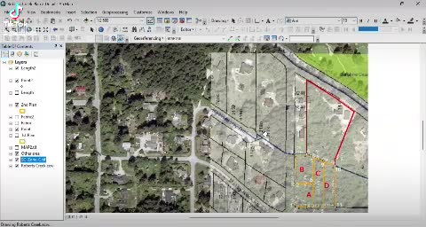
Do you have an old scanned map or raster image that you want to convert into a geo-referenced digital map?
I will accurately georeference your raster map (e.g., scanned topo maps, historical maps, or paper maps) using ArcMap (ArcGIS Desktop) and export it as a high-resolution, geo-referenced PDF map with georeference information retained inside the PDF file.
What I offer:
What you will receive:
Ideal for:
Feel free to consult before ordering. Let's make your old maps powerfully useful for your data visualization needs
ArcMap Expert for Your GIS Projects
Languages
Can you georeference a JPG image?
Yes! Any format can be used for georeference, JPG, PNG, TIFF, PDF, or any other format. All you need is to tell me where the exact location of the image.
I need to overlay 2 image into a map. Can you do this?
Yes, you can order Gold package to make those images overlayed into a georeferenced PDF map. Additionally you can choose Platinum package for more than 2 images
I need to draw my custom polygon into map, can you do this?
Yes, of course. All you need is to provide a sketch or an image and tell me where you want it to be
Can you make it to another format such as MXD, KMZ/KML or SHP files, so i can edit it later?
Yes, just add another gig extra for other formats, prices are negotiable