Browse categories
English
$
USD
Connect to your AI



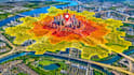
Do you need an isochrone map or travel-time analysis for a business location, research project or accessibility study? Do you need an isochrone map or travel-time analysis for a business location, research project or accessibility study? I create isochrone maps, drive-time maps and travel-time maps that show reachable areas from selected locations.
MY SERVICE INCLUDE
Whether you need to compare business locations, examine access to public facilities or visualize travel-time zones around a particular place, I can organize the geographic information into clear and useful maps.
I work with suitable location data and road-network information to prepare map outputs based on your project requirements.
Send your locations, preferred travel times and project details to get started.
professional map illustrator
Languages
What is an isochrone map?
An isochrone map shows the area that can be reached from a starting location within a specified amount of time, such as 5, 10, 15 or 30 minutes.
What information do you need to start?
I need the starting address or coordinates, preferred travel-time intervals, travel mode, and any available location or road-network datasets.
Can you create driving and walking maps?
Yes, depending on the available routing data and supported mapping services.
Can you compare multiple locations?
Yes. I can create maps comparing the travel-time coverage of multiple selected locations.
Can you create maps with different travel-time zones?
Yes. I can map several intervals, such as 5, 10, 15 and 20 minutes, depending on the project scope.