Browse categories
Explore
Fiverr Pro
English
$
USD


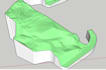
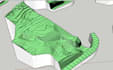
I will create an accurate 3D terrain model from your survey or contour data.
This service is suitable for:
- Civil engineering projects
- Road and infrastructure design
- Land development planning
- Site analysis and grading
I can process your data (AutoCAD, PDF, or point data) and convert it into a clean and precise 3D contour model.
What you will get:
- Accurate 3D terrain model
- Clean contour surface
- Ready-to-use file for further design (SketchUp / CAD)
Why choose me?
- Civil engineering background
- Understand contour, elevation, and site conditions
- Detail-oriented and accurate modeling
Please contact me before placing an order to discuss your data format.
Lets turn your survey data into a precise 3D terrain model.
Please inform the freelancer of any preferences or concerns regarding the use of AI tools in the completion and/or delivery of your order.
Bring your architectural designs to life in 3D
Languages


