Browse categories
Explore
Fiverr Pro
English
$
USD


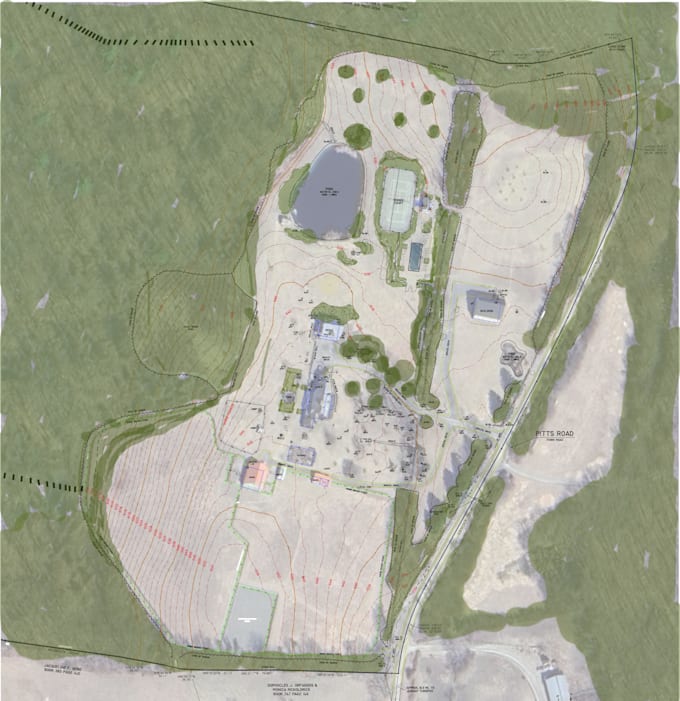
Message me before placing an order. GIS parcel and topographic mapping for land development and permit drawings for Civil engineers needing help with permit maps, parcels, contours, GIS layers.
Permit maps get rejected when parcel lines, topo, or labels arent clear. I prepare clean GIS maps that match what reviewers expect.
What I Deliver
Who This Is For
How I Work
You provide source data. I clean, align, and structure layers correctly.
Tools / Formats
ArcGIS Pro, QGIS
Outputs: PDF, DWG, SHP, GeoPackage
Turnaround / Communication
Clear scope first. Updates when needed. On-time delivery.
Please inform the freelancer of any preferences or concerns regarding the use of AI tools in the completion and/or delivery of your order.
GIS Developer, Map Maker
Languages
Is this a legal or certified survey?
No. This is a permit GIS map service for planning and development. I do not provide legal or licensed land surveys.
What do you need to create my permit GIS map?
Parcel or survey data, project location, elevation source (if available), and required output format. This allows me to prepare a clean parcel and topographic map.
Can you create parcel and topographic maps for permits?
Yes. I create parcel maps and topographic maps used for land development and permit submissions.
What software do you use for GIS mapping?
I use ArcGIS Pro and QGIS to prepare accurate land development GIS maps.
Will this GIS map be accepted for permit submission?
I prepare permit-ready GIS maps that match common planning requirements. Final approval depends on your local authority and source data.
What file formats will I receive?
PDF for submission plus GIS formats such as SHP, DWG, or GeoPackage on request.
Do you offer revisions?
One revision is included for the same permit GIS map scope. Additional parcels or layers are treated as extras.
Can you deliver a land development GIS map urgently?
Yes. Rush delivery is available for permit deadlines.
What services are not included?
Legal land surveys Field data collection Conceptual site planning Guessing missing parcel or topo data