Browse categories
Explore
Fiverr Pro
English
$
USD


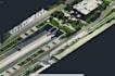
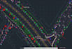
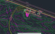


I deliver highaccuracy point cloud to CAD drafting for surveyors, engineers, and construction professionals who require precise, standardscompliant results. I convert LAS, LAZ, E57, and RCP files into clean, georeferenced 2D CAD drawings using AutoCAD, Trimble Business Center, Civil 3D, and Metashape. My expertise includes topographic survey plans, asbuilt documentation, utility mapping, contour generation, and detailed feature extraction for industrial, municipal, and infrastructure projects. With 10+ years of experience on UAE projects such as KEZAD, AD Ports, LRT4 Railway, and Yas Island developments, I follow structured layer management and can match any client or authority standard. Whether you need a small area drafted or a large, complex site processed, I provide reliable timelines, professional communication, and Prolevel accuracy for all point cloud and surveybased CAD deliverables.
Please inform the freelancer of any preferences or concerns regarding the use of AI tools in the completion and/or delivery of your order.
Survey Draftsman
Languages
Can you match my CAD standards or authority requirements
Yes. I can follow your company templates or match standards such as KEZAD, AD Ports, municipal requirements, or any custom layer structure you provide.
Do you provide georeferenced CAD drawings?
Yes. If your point cloud or survey data includes coordinates, I will align and deliver fully georeferenced CAD files. Q: What level of detail can you extract from the point cloud? I can extract topographic features, edges, utilities visible in the cloud, curbs, roads, structures, and elevation detai


