Browse categories
English
$
USD
Connect to your AI

I'm a VCU urban planning grad student and a Wilder Fellow at Richmond International Airport. I make maps that are accurate, clean, and easy to read.
WHAT I MAKE
- Locator and reference maps for reports and proposals
- Census ACS thematic maps (income, vehicle access, commuting, housing)
- Spatial analysis: buffers, overlays, rates, hot spots (Gi*)
- Print-ready layouts up to 11x17 at 300 dpi
WHY ME
I use only official data: U.S. Census (ACS, TIGER/Line), state DOTs, and city and county open-data portals. Every map includes a source list with the dataset, year, and link, so you can cite it with confidence.
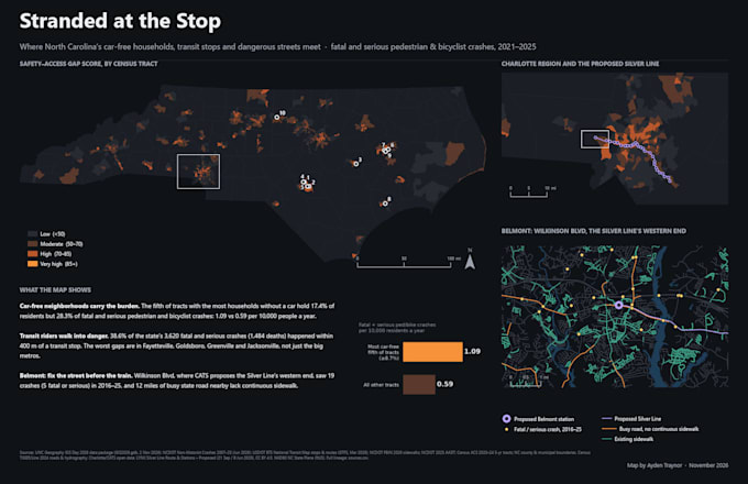
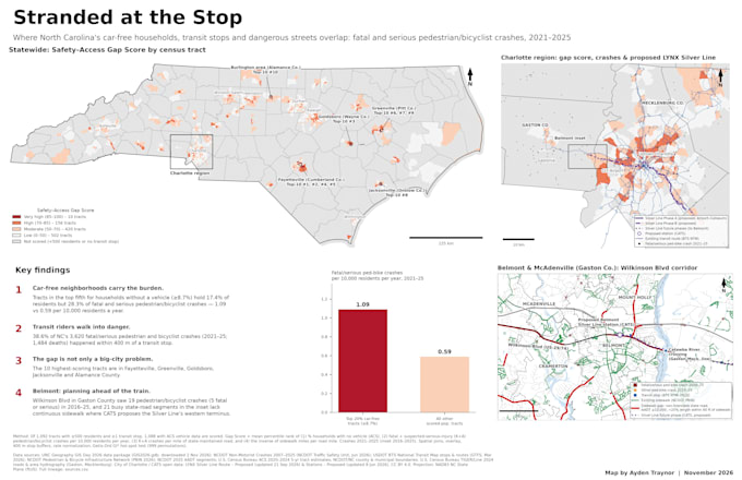
Recent work: "Stranded at the Stop," a statewide NC analysis of pedestrian safety near transit stops (ArcGIS Pro, NCDOT crash data, ACS).
GREAT FOR
Nonprofits, planners, students, researchers, small businesses, and community groups.
BEFORE YOU ORDER
Message me with your area, the question the map should answer, and where it will be used (print, slides, or web). I'll confirm scope and timing first.
GIS Analyst and Cartographer
Languages
What data do you use?
Only official sources: U.S. Census (ACS, TIGER/Line), state DOTs, federal agencies, and city or county open-data portals. I don't use OpenStreetMap or hand-drawn data unless you request it, and if you do, it's labeled.
Can I use the map commercially?
Yes. Census data is public domain. If a local dataset needs attribution, I will add the credit line for you.
Can you use my data?
Yes: spreadsheets with addresses or coordinates, shapefiles, GDB, GeoJSON, or KML. Large geocoding jobs may be quoted separately.
What software do you use?
ArcGIS Pro. I can deliver files that open in QGIS or ArcGIS Online.
Custom print sizes?
Yes. I design at the final size and export at 300 dpi. Posters larger than 11x17 can be quoted.