Browse categories
Explore
Fiverr Pro
English
$
USD

Level 2
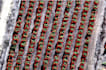
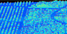
Do you need accurate per-tree mapping and analysis from LiDAR data?
I specialize in Individual Tree Crown (ITC) Delineation, turning raw LiDAR point clouds into actionable spatial data for forestry, agriculture, and environmental projects.
With my service, you will get:
Individual tree crown shapefiles (each polygon represents one tree).
Unique Tree IDs for tracking across multiple flights or seasons.
Crown area, centroid coordinates, and other attributes for every tree.
Digital orchard or forest maps for management and reporting.
Applications:
Deliverables:
Mapping Specialist
Level 2
Languages
Can you create a farm spatial database for individual trees in my orchard?
Yes, I can get all the attributes of each tree and create a monitoring database
What if I do not have lidar data, can you use drone images?
Yes, I can use point clouds from the overlapping drone images
Can you do forest biomass estimation and yield estimation?
Yes I can


