Browse categories
Explore
Fiverr Pro
English
$
USD

Level 1

If you're looking for GIS services using ArcMap, I offer a variety of options:
1. Geo Spatial Analysis:
- Buffer creation
- Clip analysis
- Extraction by mask
- Topological error removal
- Spatial operations like Join, Union, and Intersection
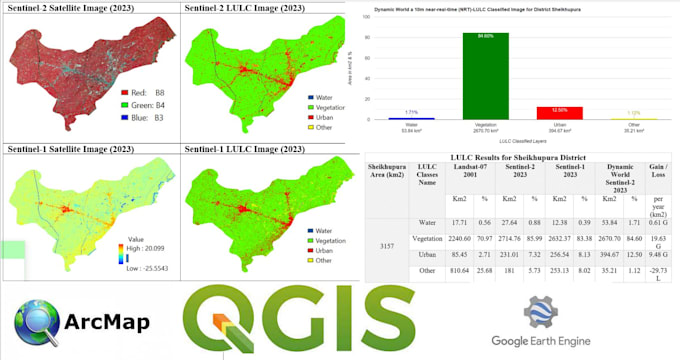
2. Land Use Land Cover Mapping
3. Attributes Entry and Data Sorting:
- Based on attributes
4. Vectorization & Rasterizations
5. Image Analysis:
- Classification
- Spectral Indices (e.g., NDVI, NDWI)
- Image Composite
6. Model Builder Task
7. Thematic Map Creation
8. Data Conversion Tools:
- Shapefile, Feature Class, Geodatabase, KML
- Coordinate System and Projection adjustments
9. Digitization + Georeferencing
10. Watershed Analysis
Feel free to reach out before placing an order to discuss your specific needs. I'm here to help with any GIS-related questions or requests you might have.
GIS and RS Analyst Python Google Earth Engine Arcpro Qgis
Level 1
Languages
Can you explain Geo Spatial Analysis briefly?
Geo Spatial Analysis involves examining spatial relationships within geographic data. This includes operations like buffering, clipping, and spatial joins for in-depth analysis.
What is GIS?
GIS stands for Geographic Information System. It's a technology that captures, analyzes, and presents spatial or geographic data.
How does Image Classification work in GIS?
Image Classification involves categorizing pixels in a satellite or aerial image into different classes, helping identify features like vegetation, water, or urban areas.
What is Watershed Analysis?
Watershed Analysis assesses the flow of water over a specific area, identifying contributing factors and helping in water resource management.
What kind of data can be converted using Data Conversion Tools?
Data Conversion Tools are used to convert between different GIS data formats, such as Shapefiles, Feature Classes, Geodatabases, KML, and managing coordinate systems and projections.