Browse categories
Explore
Fiverr Pro
English
$
USD


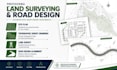
Create site plan, topographic survey drawings, land survey & road design alignment with accurate CAD drafting, contours & permit-ready files.
Need professional site plan, topographic survey drawings, land survey, or road design alignment services for your project? I help architects, contractors, engineers, and property owners get accurate, permit-ready drawings that save time, reduce revisions, and improve project efficiency.
Services Included
Why Choose Me?
Tools & Software
AutoCAD Civil 3D, AutoCAD, ArcGIS, Carlson Survey, GIS & mapping tools.
I deliver high-quality site plans, topographic survey drawings, land survey drafting, and road alignment designs tailored to your project needs.
Message me now for a FREE consultation before placing your order!
Please inform the freelancer of any preferences or concerns regarding the use of AI tools in the completion and/or delivery of your order.
Land Surveyor Site Plan and AutoCAD Mapping Expert
Languages
