Browse categories
Explore
Fiverr Pro
English
$
USD


Stop guessing and start managing your farm with precision data.
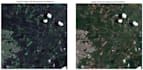
As an Agricultural Engineer specializing in Geospatial Analysis, I help farmers and agribusinesses transform satellite imagery into actionable insights. Using high-resolution Sentinel-2 data (10m/pixel) and advanced GIS processing, I provide a clear picture of your crops health and variability.
Why choose this Gig? Unlike standard data analysts, I provide an engineering perspective. I don't just send you a "pretty map"; I interpret the data to help you identify zones of stress, optimize inputs, and maximize your yield.
What you will get:
How it works:
Please note: This service covers
Languages
What information do I need to provide?
I only need the location of your farm. You can send a Google Maps link, GPS coordinates (Latitude/Longitude), or a KML/KMZ file of your field boundaries.
What is the resolution of the imagery?
I primarily use Sentinel-2 satellite data, which offers a 10-meter per pixel resolution. This is ideal for medium to large-scale farm management and identifying spatial variability.
Can you analyze any type of crop?
Yes! Whether it's grains, orchards, or industrial crops, the multispectral analysis works by measuring biomass and chlorophyll activity, which applies to almost all vegetation.


