Browse categories
Explore
Fiverr Pro
English
$
USD


Are you searching for professional GIS and Remote Sensing services?
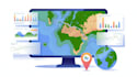
You're in the right place. I am Brad Greg, a GIS & Remote Sensing specialist with over 7 years of international experience helping clients in real estate, environment, infrastructure, and agriculture make smarter, location-based decisions. I provide GIS mapping and spatial analysis for site selection and zoning, remote sensing for land cover change, biomass modeling, REDD+/ARR support, and environmental risk assessments. I also develop Web GIS solutions and interactive map visualizations using tools like ArcGIS Online and Leaflet, as well as data engineering and automation pipelines for efficient workflows. My services include environmental and watershed management (watershed delineation, flood risk, landslide susceptibility), statistical and spatial analysis (weighted overlays, geostatistics, trend analysis), remote sensing and image processing (classification, mosaicking, enhancement), cartography and mapping (thematic maps, georeferencing, parcel digitization), and geoprocessing tasks such as buffering, clipping, intersection, raster-vector conversion, and KML/KMZ creation.
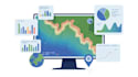
GIS Geospatial Analysis Spartial
Languages
Q1. What do you need to start?
I need your data (even rough) and project requirements. Ideally, provide coordinates, attributes, or any files (Excel, shapefiles, GeoTIFF). If you don’t have data, I can help find public datasets (in the Standard/Premium package).
Q2. Which software do you use?
I primarily use ArcGIS Pro and QGIS (both industry-standard GIS). For satellite imagery and big data, I use Google Earth Engine, and for custom analysis I use Python/MATLAB.
Q3. What will I receive?
You’ll get clear maps (PDF/PNG/GeoPDF) and any requested data files.Charts or a summary report. All layers in a GIS-readable format if needed.
Q4. Can you do remote sensing or image analysis?
Yes! I can process satellite imagery (Landsat, Sentinel), create NDVI maps, LULC classification, heatmaps, etc.
Q5. Do you offer 24-hour delivery?
I can deliver Basic in 24 hours if the task is simple (e.g. single-layer map). For more complex analysis (Standard/Premium), I need 2–5 days to ensure accuracy.
Q6. Why should I hire you?
I combine technical GIS skills with clear communication. I’ve completed similar projects for clients worldwide, and I focus on your exact goals (e.g., getting that job, winning a grant, making data-driven decisions). I guarantee fast response and on-time delivery.


