Browse categories
Explore
Fiverr Pro
English
$
USD


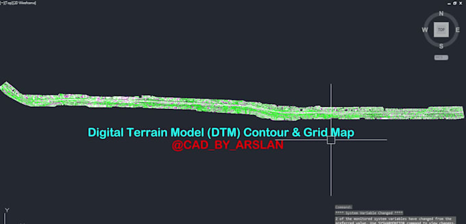
I am a professional Survey & Structural Draftsman with 7+ years of experience in AutoCAD and Civil 3D. I specialize in converting point cloud scan data into accurate CAD drawings and as-built documentation for residential, commercial, and infrastructure projects.
I can create:
I work with point cloud formats such as RCP, RCS, E57, LAS, XYZ, and deliver clean, organized, and professional DWG/PDF files.
Why choose me?
Accurate drafting
Fast delivery
Professional communication
Revisions until satisfaction
Experience with UAE, US & international projects
Please contact me before placing an order so we can discuss your project requirements, timeline, and pricing.
Fiverr does not screen freelancers in this category. Please verify qualifications and discuss requirements with the freelancer before ordering, including any preferences regarding the use of AI tools.
Accurate Surveys, Reliable Volumes
Languages
What point cloud file formats do you accept?
I accept RCP, RCS, E57, LAS, XYZ, PTS, PTX, and other common point cloud formats.
What drawings can you create from point cloud data?
I can create floor plans, elevations, sections, site plans, topographic drawings, utility drawings, and complete as-built CAD drawings.
Which software do you use?
I mainly use AutoCAD, Civil 3D, Autodesk Recap, and other survey drafting tools.
Will I receive editable source files?
Yes, editable DWG and other requested source files will be included with the delivery.
Can you handle large commercial or infrastructure projects?
Yes, I have experience working on residential, commercial, railway, and infrastructure projects.
Do you offer revisions?
Yes, revisions are included to ensure the final drawings meet your requirements.
How accurate are the drawings?
The drawings are created based on the provided scan data and project requirements to maintain high drafting accuracy.
Should I contact you before placing an order?
Yes, please contact me first to discuss project scope, file format, timeline, and pricing before placing the order.