Browse categories
Explore
Fiverr Pro
English
$
USD


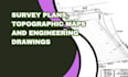
Need accurate survey plans, topographic maps, and engineering drawings for your UAE project?
I deliver precise, municipality-approved survey documents for property developers, architects, engineers, and contractors across Dubai, Abu Dhabi, and the UAE.
Why Choose Me? UAE Authority Ready Dubai Municipality, DMT, Trakhees compliant Survey-Grade Precision Accurate data you can trust Fast Delivery 3-7 days Multiple Formats PDF, DWG, GIS shapefiles
Message me before ordering with your plot details!
Please inform the freelancer of any preferences or concerns regarding the use of AI tools in the completion and/or delivery of your order.
PROJECT MANAGEMENT AND PLANNING
Languages
Do you provide on-site surveying or only drawings?
I provide drafting services using your data. For field surveying, I can recommend trusted UAE partners.
What coordinate system do you use?
UTM/WGS84 (standard for UAE projects). Just specify if you need a different system.
Are your drawings accepted by Dubai Municipality?
Yes! All plans comply with Dubai Municipality, DMT, and Trakhees requirements.
