Browse categories
Explore
Fiverr Pro
English
$
USD


Get a Clear, Permit-Ready Site Plan Without Costly Delays
Permit rejections, unclear layouts, and repeated city feedback can slow down any land or subdivision project. This service helps you move forward with clear, accurate site plans and lot subdivision drawings designed to meet city permit and planning requirements.
Whether you're developing land, subdividing property, or preparing documents for approval, you'll receive well-structured AutoCAD drawings that are easy to review, submit, and revise if needed.
What This Service Solves:
What Youll Receive:
Final Deliverables:
Message now with your land details and permit needs, and lets get your site plan ready for approval without the delays.
Fiverr does not screen freelancers in this category. Please verify qualifications and discuss requirements with the freelancer before ordering, including any preferences regarding the use of AI tools.
Languages
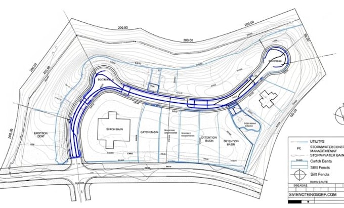
What are subdivision grading and drainage drawings?
They are civil engineering plans showing how a subdivision’s land will be graded (sloped), drained, and protected from erosion during and after construction.
Why are they important?
They ensure compliance with municipal codes, prevent flooding, protect water quality, control erosion, and provide safe, stable lots for building.
What do grading plans typically show?
Existing and proposed contours Spot elevations at lot corners, roadways, and key drainage points Finished floor elevations of buildings Slopes and swales for proper drainage
What do drainage plans include?
Storm sewer systems and inlets Overland flow paths Detention/retention ponds Culverts, channels, and stormwater outfalls
What is included in erosion and sediment control drawings?
Silt fences, check dams, and sediment basins Construction entrances Temporary seeding and stabilization methods Phased construction sequencing
Who prepares these drawings?
Licensed civil engineers or land development consultants, often working with surveyors and environmental specialists.
What approvals are required?
Typically reviewed and approved by local planning, engineering, or stormwater management agencies before construction permits are issued.
What software is used?
AutoCAD Civil 3D, MicroStation, or GIS based tools are common for preparing detailed grading and drainage drawings.