Browse categories
Explore
Fiverr Pro
English
$
USD


Turn Raw Data into Tactical Geospatial Intelligence.
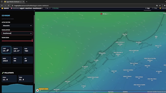
Standard weather apps are for commuters. My dashboards are for Decision Makers. I am a GIS Developer specializing in building high-performance, real-time monitoring systems. Using a "Tactical OS" aesthetic, I transform complex meteorological and geospatial data into a seamless, hardware-terminal style interface designed for operational awareness.
Whether you are managing maritime routes in the Atlantic, agricultural sectors in the Midwest, or logistics hubs in Europe, I build the tools you need to see the "Big Picture" with zero latency.
What I deliver:
Choose to pay for your project per milestone by only paying when it’s time to start a new one or decide on a 1-time payment.
I'll create the design for your website.
I'll develop the website and deliver a working product for your review.
Please be aware that it is against Fiverr's policies for sellers to include themes, templates, or any other elements that infringe third-party rights or applicable laws in the delivered work. Read more about in our Guide to Responsible Digital Creation.
GIS Developer
Languages
Can this dashboard monitor any location globally?
Yes. The system is built on a universal coordinate framework ($Lat/Lon$). I can configure the dashboard for any specific city, offshore maritime zone, or remote operational sector worldwide.
What makes a "Tactical" dashboard different from a standard weather website?
Traditional websites are built for casual viewing. My "Tactical" dashboards are engineered for operational density.
Which APIs and technologies do you use?
The core engine is built in Python using Streamlit for the UI. I primarily use high-precision, open-source APIs like Open-Meteo to keep your operational costs at zero. For mapping, I integrate Windy, Mapbox, or Leaflet to provide live satellite and radar overlays.
Do I need to pay for monthly hosting?
Not necessarily. I can deploy your dashboard to the Streamlit Cloud or HuggingFace for free. For enterprise-grade security or custom domains, I can assist with deployment on AWS, GCP, or Azure (available in the Premium package).
Can I integrate my own proprietary data or sensors?
Absolutely. If you have private CSV/JSON feeds, IoT sensors, or local database records, I can build a custom "Data Intelligence Engine" to merge your internal data with global meteorological feeds. Please message me before ordering to discuss technical requirements.