Browse categories
Explore
Fiverr Pro
English
$
USD


⭐ FREE project consultation before order
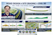
Professional Civil 3D Road Design, Site Grading and Drainage Plans
Hello,
I am a Civil CAD Designer with strong experience in Autodesk Civil 3D. I specialize in preparing road design drawings, site grading plans, drainage layouts and detailed engineering drawings for contractors, surveyors and design consultants.
I can help you convert survey data, point clouds, or existing drawings into accurate Civil 3D design models and construction drawings.
My Services Include:
Road Alignment Design
Road Plan and Profile Drawings
Cross Sections Creation
Surface Creation from Survey Data
Site Grading Plans
Drainage Layout / Stormwater Network
Earthwork and Volume Calculations
Civil 3D Corridor Modeling
Conversion of Survey Data into Civil 3D Surfaces
I Can Work With:
Deliverables
If your project is large or complex, please contact me before placing the order so we can discuss the project scope.
I look fo
Please inform the freelancer of any preferences or concerns regarding the use of AI tools in the completion and/or delivery of your order.
Specializing in LiDAR Processing, GIS Mapping, and Civil 3D Design and Drawings
Languages
What files do you need to start the project?
Survey points, CAD drawings, GIS data, or point cloud files such as E57, LAS, or RCP.
Do you provide Civil 3D source files?
Yes, I provide Civil 3D DWG source files along with PDF drawings.
Can you create surfaces from survey data?
Yes. I can create Civil 3D surfaces from survey points, contours, or point clouds.
Can you design drainage networks?
Yes. I can design basic storm water drainage layouts and pipe networks in Civil 3D.


