Browse categories
Explore
Fiverr Pro
English
$
USD
PhD Researcher in Remote Sensing, GIS and Geospatial AI
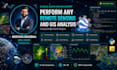
Are you working with satellite data and need a powerful Google Earth Engine solution?
I will develop a complete GEE solution tailored to your exact needs, from a simple script to
a full interactive platform.
What I offer:
Satellite data access, filtering & selection
Image preprocessing & cloud masking
Spectral index computation (NDVI, NDSI, EVI, NDWI...)
Land cover & change detection analysis
Time series analysis & trend monitoring
Classification & segmentation workflows
Accuracy assessment & validation
Data visualization & chart generation
Interactive GEE app development
Automated export to Google Drive or Assets
Full workflow documentation & clean code
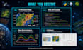
What you receive:
Clean, commented, reproducible GEE code
Shareable GEE script or app link
Professional maps & charts
Full methodology & results report
Why choose me?
PhD researcher in Remote Sensing & Geoinformatics with 5+ years of hands-on experience in Google Earth Engine for environmental, agricultural, and hydrological applications.
I work in English and French.
Message me before ordering to discuss your data and project needs!