I will process and interpret drone survey data

E
elezen_gis
E
elezen_gis
Alen Gis

Level 1

About this gig

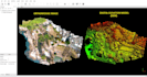
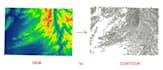
Related to Drone survey data, following services will be provided:


- Survey Planning (Survey Grids) Using UAV's with GCP's Marking.


- Drone Data processing with or without Ground Control Points.


- Orthomosaic, DEM I DTM I DSM generation


- Contours Generation


- Point Cloud


- Complete Digitization (GIS shapefile or CAD Drawing)


- High Processing Systems with ability to process Hundred GBs of Data.


Discuss the project before placing order.

Get to know Alen Gis

Alen Gis
4.5(13)

Level 1

  • FromPakistan
  • Member sinceSep 2023
  • Avg. response time1 hour
  • Last delivery1 day
  • Languages

    English
Hi there, ALEN GIS is a recognized GIS mapping and analysis experts team aimed at providing technical map making services, GIS 2d and 3d modelling, data analysis and various types of spatial analysis to its valuable clients and aid in the completion of many major projects and challenging tasks.

Related tags