Browse categories
Explore
Fiverr Pro
English
$
USD

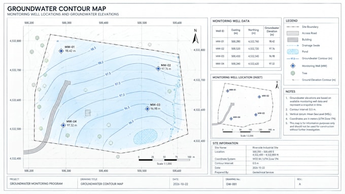
Need a groundwater contour map for your project? I will draft it from supplied measurements, well coordinates, and site plan.
Your map can include:
Monitoring-well locations and IDs
Groundwater elevation labels and contour lines
Site boundaries, coordinate grid, north arrow, and scale bar
Legend and title block
Monitoring-data table, if required
Please provide well coordinates, groundwater levels or elevations, measurement dates, a base map, coordinate reference system, preferred contour interval or method, and file format. I will review the files and confirm scope before starting.
Deliverables may include a PDF and editable source file, depending on software requirements.
I work from client-provided information. I do not collect field data, invent missing values, verify site conditions, or provide independent hydrogeological conclusions. Contours require suitable data and an agreed method.
Message me before ordering if coordinates are missing, units conflict, multiple dates are involved, or GIS processing is needed. I will confirm feasibility, price, and delivery time.
Please inform the freelancer of any preferences or concerns regarding the use of AI tools in the completion and/or delivery of your order.
Geotechnical CAD Drafting Specialist
Languages
What data do you need to create a groundwater contour map?
Please provide monitoring-point coordinates, groundwater levels or elevations, measurement dates where relevant, and a base map or site boundary.
Can you create contours from a spreadsheet?
Yes, if the spreadsheet contains suitable measurements and coordinates and the required mapping method is supported by your agreed scope. Please send a sample first.
Can you show monitoring wells, labels, and groundwater elevations?
Yes. These can be included when the supplied data supports them and the selected package covers the required work.
What file formats do you deliver?
PDF is available. Editable GIS or CAD source files depend on the software used and must be agreed upon before ordering.
Do you provide groundwater investigations or professional conclusions?
No. This gig covers mapping from supplied data. Field measurements, independent hydrogeological assessments, and certified reports are excluded.
