Browse categories
English
$
USD
Connect to your AI

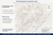

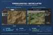
Contour lines + points d'altitude
Fichiers AutoCAD DWG
QGIS Project + SHP Shapefile
ArcGIS compatible
KML for Google Earth
PDF haute qualité + 3D terrain model
POURQUOI MOI?
Précision centimétrique
Livraison rapide
Révisions illimitées jusqu'à satisfaction
Support après livraison
Idéal pour: Construction, lotissement, route, agriculture, permis de construire.
Please inform the freelancer of any preferences or concerns regarding the use of AI tools in the completion and/or delivery of your order.
Topographe SIG ExpertAutocad covadis
Languages
Quels fichiers Je reçois?
Dwg Autocad+SPH Arcgis+PDF
Vous travaillez sans données GPS?
Oui Je peux creer à partir google earth
Livraison rapide?
Oui,option 24 heurs disponible en extrs 15$


