I will do crop classification using multi sensor remote sensing data

F
farhadullah0303
F
farhadullah0303
Farhad Ullah
5.0
5.0

About this gig

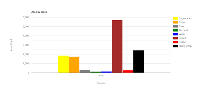
i will do crop classification using multi sensor data through Google Earth Engine, with machine learning algrothim, along with accuracy assenments.

Get to know Farhad Ullah

Farhad Ullah
5.0(3)
  • FromPakistan
  • Member sinceJan 2020
  • Avg. response time1 hour
  • Last delivery1 year
  • Languages

    English
Being a GIS expert I am abled to do any type of map mapping on geospatial data through using spatial software like arcmap, google earth, google earth engine, postgres/postgis etc. besides these can also have command on doing spatial analysis and data visualization too.
Reviews

1 reviews for this Gig
5.0

(1)
(0)
(0)
(0)
(0)
Rating Breakdown
  • Seller communication level
    5
  • Quality of delivery
    5
  • Value of delivery
    5
Sort By
Most relevant
  • U

    user21168480

    MA

    Morocco

    5

    Exemplary professionalism, meticulous attention to detail, and proactive communication. Farhad went above and beyond, delivering exceptional quality work on time. Highly recommended!

    $100-$200

    Price

    5 days

    Duration

    Helpful?
    Yes
    No