Browse categories
Explore
Fiverr Pro
English
$
USD
Its a pleasure to have you here. Let me introduce my services!!!
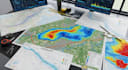
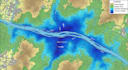
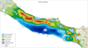
I will GIS analysis, topography, flood modeling, hydrology, hydraulics mapping.
There's a language only the land understands a language spoken in contour lines, elevation shifts, and the silent motion of water. I translate that language into data driven clarity.
What Youll Receive:
Contact Me to Begin Your Project:
Your terrain has a voice lets make it speak in data.
to turn your site into a living, mapped story of flow,

_lia5rr.jpg)
Project scale:
Building
Building type:
Residential
•
Commercial
•
Infrastructure
Please inform the freelancer of any preferences or concerns regarding the use of AI tools in the completion and/or delivery of your order.
What data sources do you use?
Official DEM, FEMA, and hydrology datasets cross-verified through ArcGIS and QGIS tools.


