Browse categories
Explore
Fiverr Pro
English
$
USD


Hi!
I am Muhammad Furqan, I am GIS Engineer with over four years of experiance. I build systems that analyze, visualize, and automate spatial data so decisions become easy.
What I Can Do for You:
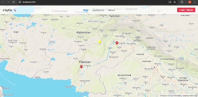
Web GIS Applications (Leaflet, Mapbox, OpenLayers, React)
GeoServer + PostGIS (WMS, WFS-T, real-time editing)
️ Remote Sensing (NDVI, LULC, Change Detection)
GeoAI & Machine Learning (Land Cover, Prediction Models)
GIS Automation with Python & Google Earth Engine
Spatial Dashboards & Smart City Solutions
Why Work With Me
Strong engineering background in Geoinformatics
Experience with real-world GIS projects
Clean code, clear maps, and practical solutions
I focus on results, not just tools
I deliver accurate maps, intelligent analysis, and scalable GIS systems tailored to your project needs.
GIS services, Online assistance
Languages
What mapping libraries do you work with?
I specialize in building custom applications using Leaflet, OpenLayers, Mapbox, and Google Maps API. I can advise you on the best technology based on your project requirements and budget.
Can you handle real-time data or large datasets?
Yes. I can integrate APIs for real-time data streams and use robust back-ends like PostgreSQL/PostGIS and GeoServer to manage and efficiently visualize large, complex spatial data sets.
What kind of data formats do I need to provide?
I can work with all standard geospatial formats, including GeoJSON, Shapefiles, KML, Excel sheet and data from a database like PostGIS. If your data is in a different format, just send me a sample, and I will let you know.
Will the application be mobile-friendly?
Absolutely. All applications I develop feature a responsive design, ensuring your WebGIS solution works perfectly on desktop, tablet, and mobile devices.
Do you provide back-end integration (Database/Server)?
Yes, I can integrate your WebGIS with a complete stack, including PostgreSQL/PostGIS for database management and GeoServer or similar services for serving complex map layers and analytics.