I will develop a full stack webgis application using ai

G
geocraft_studio
G
geocraft_studio
Geocraft Studio

About this gig

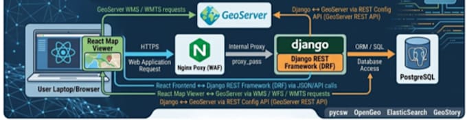
Are you sitting on geospatial data but struggling to visualize, manage, or analyze it effectively? I build custom, full-stack WebGIS applications tailored to your specific needs, leveraging artificial intelligence to automate heavy lifting and deliver smarter insights.

Whether you need a simple interactive map or a complex digital asset management system with intelligent workflows, I can architect the solution.

What I Offer:

  • Custom WebGIS Dashboards: Intuitive map viewers and metadata editors built with React.js.
  • Robust Spatial Databases: Secure and scalable backends utilizing PostGIS, MySQL, and Python/PHP.
  • AI & Automation: Integrating local AI models and workflow automation (like n8n) to streamline geoprocessing, web scraping, and spatial analysis.
  • End-to-End Development: From architecture planning to deployment.

Perfect For:

  • Real estate data tracking and lead generation platforms.
  • Environmental monitoring and urban planning (e.g., flood management mapping).
  • Custom spatial data infrastructures for enterprise teams.

Why Me? I don't just write code; I am a geospatial analyst who understands the nuances of spatial data, projections, and cartography.

Respect third-party rights

Please be aware that it is against Fiverr's policies for sellers to include themes, templates, or any other elements that infringe third-party rights or applicable laws in the delivered work. Read more about in our Guide to Responsible Digital Creation.

Get to know Geocraft Studio

Geocraft Studio

GIS Enthusiastic

  • FromPakistan
  • Member sinceJun 2026
  • Avg. response time1 hour
  • Languages

    Urdu, Punjabi, English
I am a GIS Analyst and GIS Developer specializing in spatial data analysis, geospatial application development, remote sensing, and location intelligence solutions. With experience in transforming complex geographic data into actionable insights, I help organizations make informed decisions through advanced mapping, spatial modeling, and geospatial visualization.

My Portfolio