I will design illustrated visitor maps for theme and entertainment centers

G
georgedecke
G
georgedecke
George Decker

About this gig

Hello!


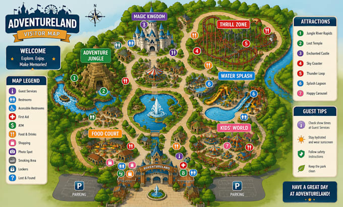
I will create a custom and visually engaging visitor map for theme parks, amusement parks, entertainment centers, resorts, zoos, museums, attractions, and recreational spaces.

A well-designed visitor map helps guests easily navigate your location while creating an exciting and memorable experience. I focus on combining clear layouts, attractive illustrations, and easy-to-understand navigation elements.


My services include:

  • Custom illustrated theme park maps
  • Amusement park attraction maps
  • Visitor guide maps
  • Entertainment center maps
  • Resort and recreational maps
  • Location icons and landmarks
  • Walking paths, zones, and attraction highlights
  • Professional map layouts for print and digital use


You will receive:

  • High-quality custom design
  • Clean and organized layout
  • Professional illustrations
  • Easy-to-read labels and navigation
  • Files suitable for web, printing, and presentations


I can transform your sketches, site plans, satellite images, or ideas into an attractive and functional visitor map that improves your guests' experience.


Please contact me before placing an order so we can discuss your project requirements and create the perfect map for your attraction.


Delivery style preference

Please inform the freelancer of any preferences or concerns regarding the use of AI tools in the completion and/or delivery of your order.

Get to know George Decker

George Decker

Site map Plot plan Subdivision Campground

  • FromUnited Kingdom
  • Member sinceJul 2026
  • Languages

    English, French, German
I’m a professional Urban Planner with over 5 years of experience in Land subdivisions, Site Layout Plans, Land Use Plan, and Master Plans. I mainly use AutoCAD Civil 3D and Revit to deliver accurate, high-quality, and professional drawings that meet design and approval standards. I’m also skilled in Adobe Photoshop, ArcGIS and Google Earth for producing detailed maps and spatial analyses.