Browse categories
Explore
Fiverr Pro
English
$
USD
Level 2


Are you looking for an experienced 1D, 2D, 3D Hydraulic Modeler & Hydrologist with GIS expertise? Look no further; I offer a wide range of services to support your project needs.
My HEC-RAS modeling service will model steady flow and unsteady flood scenarios (5y, 10y, 50y, 100y), enabling you to predict and mitigate potential risks.
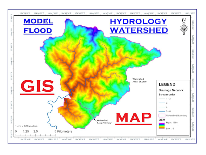
My hydrology service provides detailed analysis of water behavior in the catchment area, helping you understand water supply dynamics, stream network, topography, bathymetry, slopes, elevation difference, irrigation, and potential flood hazards.
My drainage network and watershed analysis will give insights into the topology, water flow, distribution, stream order, and delineating catchment boundaries.
My GIS mapping service is for detailed maps of water resources including catchment boundaries, inundation maps, elevation, TIN, DEM, flood zones, and more.
With my expertise, you can make informed decisions about land planning, infrastructure development, dam site selection, river analysis, and water management.
I am committed to providing high-quality work. I offer fast turnaround times and excellent customer service.
CONTACT BEFORE ORDER
Pro Experts in GIS, Mapping, 3D Models, Drones, and Civil Engineering
Level 2
Languages
What software do you use for flood modeling and GIS hydrology?
I utilize industry-standard GIS software such as ArcGIS and QGIS for hydrology analysis and mapping. For flood modeling, I use tools like HEC-RAS and other specialized software to ensure accurate simulations.
Can you customize your services to fit specific project requirements or geographic regions?
Yes, I tailor my modeling services to meet the unique needs of each project. Whether it's a local watershed or a larger catchment area, I adapt my methodology and analysis to suit the specific conditions and requirements provided.
How long does it take to complete a typical project?
The timeline varies depending on the complexity and scope of the project. I provide estimated delivery times based on project specifics and can discuss turnaround times to meet your deadlines.
What information do you need from clients to start the modeling process?
I typically require GIS data (such as DEMs, land use maps, and hydrological data), project specifications, and any relevant details about the project area. Clear communication about your project goals is also crucial.
What is Hydrology?
Water is one of our most precious natural resources. Without it, there would be no life on earth. Hydrology has evolved as a science in response to the need to understand the complex water system of the earth and help solve water problems.
What Hydrologists Do?
Hydrologists apply scientific knowledge and mathematical principles to solve water-related problems in society: problems of quantity, quality and availability. Hydrologists are concerned with finding water supplies for cities or irrigated farms, or controlling river flooding or soil erosion.
Do you provide reports or documentation with your modeling results?
Yes, I provide detailed reports and documentation summarizing the modeling process, findings, and recommendations. These documents help you understand the results and make informed decisions.