Browse categories
Explore
Fiverr Pro
English
$
USD


Struggling with spatial data or WebGIS integration? I've helped 40+ clients simplify complex geodata and launch scalable mapping apps using open-source & cloud tools.
Need to build a powerful GIS app, automate geospatial workflows, or turn satellite data into decisions? I help startups, researchers, and enterprises unlock the full potential of spatial data from ground to cloud.
Why Clients Hire Me:
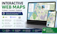
Full-Stack GIS & Web Mapping Solutions
From sleek React-based maps with Leaflet/Mapbox/OpenLayers to robust backends with PostGIS + GeoServer, I develop intuitive and scalable mapping platforms.
Cloud & Automation Expert
As an AWS DevOps Cloud Practitioner, I deploy GIS apps efficiently on cloud environments, with Python/Bash automation to save you time and reduce errors.
Proven Track Record
6+ years of experience
40+ successful GIS projects completed
Recent Projects Include:
Web-based NDVI Dashboard for crop monitoring (React + Mapbox + PostGIS)
Flood Risk Mapping using remote sensing & machine learning (QGIS + Python)
Geospatial API for Land Use Queries (FastAPI + PostGIS + GeoServer)
3D Mapping with CesiumJS for urban planning.
GIS Development, GIS Analysis, Cartography, Web Mapping
Languages
