Browse categories
Explore
Fiverr Pro
English
$
USD

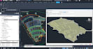


What I do: I will create a professional site grading plan, handle your earthworks calculations, and provide comprehensive civil 3D modeling for your infrastructure and road projects.
My Services Include:
Why Choose Me?
What I Need From You:
Contact before placing an order to discuss the scope of the project. Best Regards, Hagy
Please inform the freelancer of any preferences or concerns regarding the use of AI tools in the completion and/or delivery of your order.
Languages
What file formats do you accept for the survey data?
I accept survey data in CSV, TXT, Excel, or standard DWG/DXF point formats. If you have a different format, please contact me to check if I can work with it.
What file formats will I receive upon delivery?
You will receive the source file in Civil 3D format (.DWG), along with PDF files for the site grading plans, cross-sections, and quantity summary sheets.
Do I need to contact you before placing an order?
Yes, it is highly recommended. Every project has a different scale and complexity. Discussing your project beforehand helps me understand your specific needs and offer you the most accurate price and timeframe.
Can you calculate cut and fill volumes accurately?
Absolutely. With my background as an Estimator, I provide precise earthworks calculations for cut and fill quantities, complete with detailed cross-sections and summary sheets.
Do you provide revisions if I need changes?
Yes, I want to ensure the final output meets your project requirements. We can discuss adjustments to the grading plan or surfaces if needed.
Can you handle large-scale infrastructure or road projects?
Yes, I can handle various project sizes. However, for large-scale or highly complex topographical data, please message me first so we can agree on an appropriate delivery schedule.


