I will download high resolution satellite imagery

H
haidifathur
H
haidifathur
Haidi Fathur R

About this gig

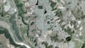
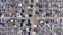
I provide high-resolution satellite imagery downloads that are ready to use in GIS software.

Perfect for mapping, visualization, planning, and reports.


Sources may include Google, Bing, or other public imagery platforms (for visualization and mapping purposes only).

Get to know Haidi Fathur R

Haidi Fathur R

Smart Solutions in GIS, Excel Automation, and Web Development

  • FromIndonesia
  • Member sinceJun 2024
  • Languages

    Indonesian, English
I am a GIS and Data Specialist with over 7 years of experience in spatial data handling—4 of those as a professional in urban and regional planning projects. I specialize in GIS-based analysis, thematic cartography, and geospatial solutions using ArcGIS, QGIS, and related tools. In addition, I have 3+ years of experience in data entry and data analysis, with a strong command of Microsoft Excel (including advanced formulas and VBA scripting). Recently, I’ve also developed a growing interest in AI, and for the past year, I’ve been exploring ways to integrate AI into interactive web applications

My Portfolio