Browse categories
Explore
Fiverr Pro
English
$
USD
Need an expert geospatial annotator for your remote sensing or mapping models? You are in the right place!
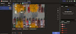
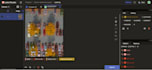
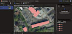
I specialize in high-precision drone survey annotation and aerial image segmentation. I bridge the gap between GIS data and machine learning by using QGIS to handle heavy orthomosaics and Label Studio for pixel-perfect vector mapping.
What I Offer:
- Drone Survey Annotation: Roof boundaries, building footprints, road networks, and infrastructure tagging.
- Semantic Segmentation: Multi-class labeling for land cover, forestry, and water bodies.
- Precision Polygons: Clean, gap-free edge tracing that handles obstructed features flawlessly.
- Format Compatibility: Error-free vector datasets exported to COCO JSON, YOLO, or Shapefile-ready formats.
Why Choose Me?
- Certified dataset pipeline training via DataLens Africa.
- Advanced mastery of QGIS (for geospatial image tiling) and Label Studio.
- Multi-step manual quality assurance to eliminate label noise.
Please drop me a message with your project guidelines and image samples before placing an order. Let's build clean mapping data together!
Technique:
Manual
Tagging type:
Image
•
Video
Do you handle massive, heavy GeoTIFF files?
Yes! You do not need to compress your files. I use QGIS to tile heavy drone orthomosaics into web-optimized image patches (512x512 or 1024x1024 pixels) so they can be accurately labeled in Label Studio without losing spatial resolution.
What vector features do you specialize in labeling?
I specialize in drawing pixel-perfect polygons for building footprints, roads, agricultural crop zones, water bodies, and vegetation boundaries.


