Browse categories
English
$
USD
Connect to your AI


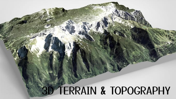
Need a realistic 3D terrain map, detailed topographic map, or custom shaded relief model? I can turn your location, map reference, or elevation data into a professional 3D terrain model tailored to your project.
I specialize in realistic 3D terrain landscapes, 3D topographic maps, elevation models, shaded relief maps, 3D relief models, and custom landscape modeling. Whether you need mountain terrain, valleys, islands, coastlines, city terrain, or a printable terrain STL, I focus on clean geometry, accurate-looking elevation, and well-defined terrain details.
MY SERVICES INCLUDE:
Please share your location, reference images, map data, preferred file format, and project requirements before ordering. I'll review your needs and confirm the scope, price, and delivery time.
Lets turn your terrain idea into a detailed 3D model you'll be proud to use.
3D city map, 3d terrain model, topographic maps, relief models, shaded maps
Please inform the freelancer of any preferences or concerns regarding the use of AI tools in the completion and/or delivery of your order.
3D Terrain, Topographic Mapping, City Maps, Relief Models, 3D Visualization
Languages
Can you create a 3D terrain model from any location?
I can work from many locations, provided suitable map references or elevation data are available. The level of geographic accuracy depends on the available source data.
Can you create shaded relief and topographic maps?
Yes. I can create terrain visualizations that emphasize elevation, contours, ridges, valleys, and other landforms.
Can you deliver an STL file for 3D printing?
Yes, where the project is suitable for STL delivery. Please provide your target dimensions and printer requirements so the model can be prepared accordingly.
Can you create realistic mountain and landscape models?
Yes. Terrain can be to the requested landscape, scale, and visual style, depending on the available references.
Can you model a city or specific geographic area?
Yes. I can discuss city terrain and geographic models based on your chosen area. Detailed buildings, roads, and landmarks may require additional work.