Browse categories
Explore
Fiverr Pro
English
$
USD


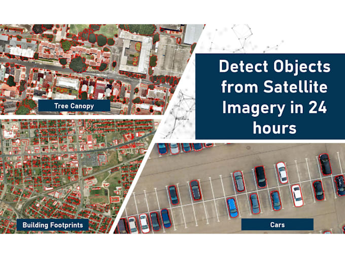
Need accurate object detection from satellite or aerial imagery in 24 hours? I specialize in fast, high-quality detection for diverse applicationsurban planning, agriculture, energy, and more.
Objects I can detect:
Buildings | Trees | Pools | Oil Pads | ️ Solar Panels | ️ Roads | Rivers/Canals | Paddy Fields | Open Land | Construction Sites | ️ Terrain | Wind Turbines | ️ Beaches | ️ Railways | ️ Campsites and more!
What Youll Get:
1.Geo-referenced vector files (GeoJSON, Shapefiles, KML)
2.Visual overlay maps (with masks or bounding boxes)
Optional: Object counts, area summaries, heatmaps
No imagery? No problem! I can assist in sourcing free or commercial satellite data for your area of interest.
Just send your area of interest and object listIll take care of the rest. Lets turn satellite data into real-world insights
GeoAI Developer
Languages
What if I don’t have satellite imagery?
No worries! I can help you source high-resolution satellite or aerial imagery from free or commercial providers based on your project needs.
What types of files will I receive?
You'll receive geo-referenced data (GeoJSON, Shapefiles, or KML) and optional image overlays (PNG/JPEG) with object detections. If needed, I can include object counts, area measurements, and summary reports.
Can you detect custom objects not listed?
Yes! Just let me know what you’re looking for. I can train or adapt models to detect specific objects for your unique project.
Do you support large areas?
Absolutely. For areas above 5 sq km, I provide custom quotes and timelines based on your specific scope.