Browse categories
Explore
Fiverr Pro
English
$
USD


I will
Create topography maps in AutoCAD and Civil 3D with contours to calculate Cut/Fill earthwork quantities, grading, and more.
Professionally convert your topographic and survey data to CAD format.
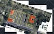
Show planimetric features like utility poles, homes, rivers, and on-ground assets.
Use GPS Points and Surveyor data to create on-ground/site assets in the drawings.
Use professional and industry-standard legends and symbols to display the drawing features.
Use survey data to create Civil 3D surfaces.
Show contours, elevations, slopes, slope arrows, and color maps.
Create 3D Surface from Surveyor Data, etc.
Create Existing Surface/Terrain Model With Contours for your Landscape or Road project.
Prepare professional site plans and terrain models.
Create Contours at specific intervals in multiple color bands.
You must send:
Data files (.dwg .dxf .csv .xls .dgn or .txt)
Format: Point number #, Easting, Northing, Elevation, Description
FREE EDITABLE DWG FILE
BEST SERVICE | BEST PRICE
Please inform the freelancer of any preferences or concerns regarding the use of AI tools in the completion and/or delivery of your order.
Languages
| (1) | ||
| (0) | ||
| (0) | ||
| (0) | ||
| (0) |
approbotics

United States
Thank you for the delivery
Up to $50
Price
1 day
Duration

| (1) | ||
| (0) | ||
| (0) | ||
| (0) | ||
| (0) |
approbotics
United States
Thank you for the delivery
Up to $50
Price
1 day
Duration


