Browse categories
Explore
Fiverr Pro
English
$
USD


Planning for a field data collection with maps, points & features?
Looking for a reliable expert to design your GIS survey forms in QField, ArcGIS Field Maps, Survey123, Mergin map, and PostgreSQL-PostGIS databases layers?
You've found the right service!
Lets make your data collection efficient, offline-capable, and fully GIS-integrated.
What You Will Get:
Advanced & Intelligent Survey Forms, including:
Skip Logic & Validation Criteria
Value Relation Widgets & Cascading Select
Rule-Based Symbology
Attribute & Expression Formulas
Smart App-Based Data Collection Tools for:
Quality Control & Data Management
Follow-up Surveys & Supervision Tools
Real-Time Feedback-Based Updates
Field-Ready GIS Data Capture, such as:
Physical Feature & Attribute Surveys
Utility Infrastructure Data (Electricity, Water, Gas, Solar)
On-site Feature Photo Capture
Map Integration & Offline Support:
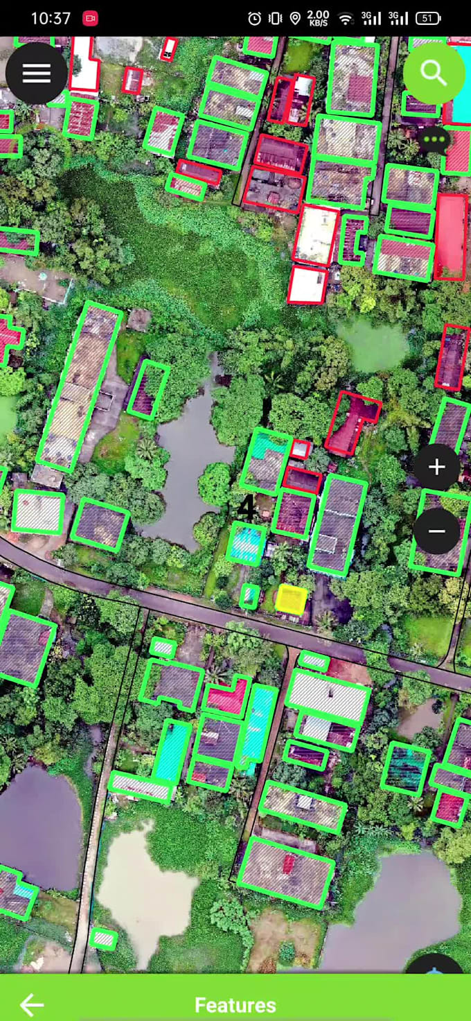
Use of Drone/Satellite Imagery as Base Maps
Offline Base Maps (Google, Bing, OSM)
Fully Offline Data Collection & Online Sync
If you're looking to make your survey forms smart, efficient, and ready to collect accurate field data I am your 'Go to Expert'!
Expert's Solution to GIS Maps and Data Collection Tools
Languages
What is QField used for?
QField is an open source mobile (Android) application that allows you to edit QGIS projects on a mobile device. It is built with the QGIS rendering engine so your QGIS project (including symbology) will look exactly the same in QField.
What is the key feature of Mergin Input?
One of the key features of Input mobile app, is the ability to upload/download your data from field through Mergin directly from the app.
Can I collect data offline and sync it later?
Yes! I provide offline-capable survey forms, which means your team can collect data in remote areas without internet access. Once they’re back online, the data will automatically sync to your online database.
Can I include maps and photos in my survey?
Yes! Your surveys can include maps, geotagged photos, and physical feature attributes. This can be extremely useful for asset mapping, environmental surveys, or utility data collection.
How do you handle Quality Control during data collection?
I set up systems for real-time quality control by integrating checks within the survey forms themselves. This includes ensuring data consistency, monitoring field progress, and providing feedback-based updates to improve data quality.
Can you use satellite or drone imagery as the base map?
Yes, I can integrate satellite or drone imagery as base maps for your survey, as well as offline base maps from platforms like Google, Bing, or OSM. This enhances your survey's context and accuracy.
How do I get started with your service?
Simply send me a message with the details of your project, and I will guide you through the process. Whether you need a simple form or a complex, multi-layered survey, I’ll ensure it’s designed to meet your needs.
Do you offer any support after the survey forms are delivered?
Yes, I offer ongoing support to ensure your survey forms function properly. Whether you need help with form updates, data syncing issues, or troubleshooting, I’ll be here to assist you.
| (1) | ||
| (0) | ||
| (0) | ||
| (0) | ||
| (0) |

fcedeno27

Panama
Excellent work. Very good person, very honest, responsible and gives beyond what you ask. I will continue working with him in the future.
| (1) | ||
| (0) | ||
| (0) | ||
| (0) | ||
| (0) |
fcedeno27
Panama
Excellent work. Very good person, very honest, responsible and gives beyond what you ask. I will continue working with him in the future.