Browse categories
Explore
Fiverr Pro
English
$
USD

Level 1
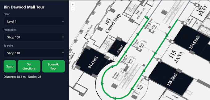

I will transform your building plans, CAD drawings, or floor plans into a fully interactive indoor map and web-based indoor navigation system. Whether you need a basic floor overlay, multi-floor mapping, indoor positioning system (IPS) integration, or advanced indoor wayfinding, I deliver modern, responsive, and user-friendly solutions.
My services cover searchable Points of Interest (POIs), multi-floor routing, access control, real-time map updates, indoor asset tracking, and custom legends & symbology. I can integrate IndoorGML, BIM models, CAD-to-GIS conversion, and vector tiles for high performance.
The indoor mapping web application is developed using cutting-edge GIS technologies such as OpenLayers, Mapbox GL JS, Leaflet, PostGIS, GeoServer, and cloud-ready deployments (AWS, Azure, GCP). Your map will work seamlessly across devices, with responsive design and options for touchscreen kiosks, mobile-friendly indoor maps, and interactive wayfinding dashboards.
Perfect for shopping malls, airports, hospitals, universities, corporate offices, factories, warehouses, government buildings, museums, and event venues anywhere you need accurate, indoor spatial data visualization.
GIS Tech
Level 1
Languages
