I will do maps using gis, machine learning deep learning analysis

I
itzaqsa
I
itzaqsa
Awais Ali

About this gig

Welcome to the GIS Remote Sensing Science!

 Assalam-o-Alaikum!

           My Self Awais Ali:

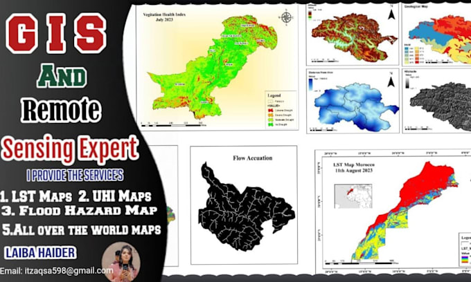
                   I am a GIS and Remote Sensing analyst with more than 4 years of experience in GIS, RS Machine learning and Deep learning. I have done many projects from creating GIS maps in several software. I have 5 years exprience as a Research Associate in punjab University, Lahore in Pakistan.

Main Software for Spatial Data Analysis:

  1.   ArcGIS MAP
  2.   Google Earth Pro
  3. Machine Learning
  4. Deep Learning
  5.   Google Earth Engine
  6.  ArcGIS Pro
  7.  ArcGIS Desktop
  8.  Erdas Imagin


Advanced GIS and Remote Sensing Analysis:

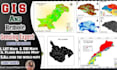
I am offering the following services for you.

  1. Land Surface Temperature
  2. Land Use Land Cover
  3. Future Predection
  4. Hotspots Map
  5. Surface Modeling Analysis
  6. Point Density Map
  7. Hydrological Modelling
  8. Network Analysis
  9. Hydrology Map
  10. Contour Map
  11. Shannon Entropy Method
  12. Downloading/Pre-processing of Satellite Images
  13. Future Prediction of Land Use/Land Cover
  14. Supervised/Unsupervised Classification

Customer Satisfaction is prioritized. Thank You!

Get to know Awais Ali

Awais Ali

I am a GIS expert

  • FromPakistan
  • Member sinceJun 2023
  • Avg. response time1 hour
  • Last delivery2 years
  • Languages

    English, Urdu, German, French
My self Awais Ali. I have completed a Bachelor's and Master's degree in GIS and, and remote sensing. I have 5 years of experience as a rsearch Assocciate and write research paper and thesis in Punjab University, Lahore, Pakistan. I make raster and vector maps all over the world. I have 5 Years of multidimensional experience in the field of GIS, Remote Sensing, Google Eartrh Engine, Machine Learning , Python and including activities like managing & capturing geospatial data, spatial data modeling & analysis, Aerial and satellite data handling, image processing & analysis, field surveys.

My Portfolio