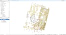
Need accurate GIS-ready data from Paper Maps or Scanned Images?
I offer professional GIS map digitizing services, converting static maps into high-quality vector data (points, lines, polygons) suitable for analysis, mapping, and spatial databases.
Services I Offer:
- Digitizing scanned or printed maps (raster to vector)
- Feature extraction (roads, buildings, land parcels, rivers, etc.)
- Georeferencing scanned maps/images
- Creating shapefiles, GeoJSON, KML, or other GIS-ready formats
- Attribute data entry (if provided)
- Map cleanup and topology correction
- Format conversion (e.g., SHP<>KML<>GeoJSON<>CSV)
Why Choose Me?
- Accuracy First: I prioritize precision and clean topology, so your GIS data is reliable for analysis.
- Quick Turnaround: I am efficient and respect deadlines, delivering your project on time.
- Clear Communication: I will ask clarifying questions to ensure I deliver exactly what you need.
Expertise: 2 years of experience in GIS
Don't let valuable data be trapped on paper. Message me today with your map!