Are you working with LiDAR data and need expert processing for terrain, vegetation, or infrastructure analysis? I offer professional, tailored LiDAR services using industry-standard tools and workflows.
Whats Included:
- Point Cloud Pre-processing
- Noise filtering, ground/non-ground classification, coordinate system alignment
- Digital Terrain Model (DTM)
- Bare-earth elevation models for topographic and hydrological analysis
- Digital Surface Model (DSM)
- Above-ground feature mapping including buildings, trees, and structures
- Canopy Height Model (CHM)
- Vegetation height analysis for forestry and ecological studies
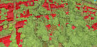
- Vegetation Classification
- Segment and classify LiDAR points by species, structure, or canopy density
- Feature Extraction
- Tree count, canopy coverage, building footprints, road networks, and more
- Contour Generation
- High-resolution elevation contours for planning and design
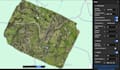
- 3D Visualization & Export
- LAS, LAZ, DXF, OBJ, GeoTIFF, or custom formats
- Custom Analysis
- Tailored workflows for your specific project goals
Tools I Use:
- DJI Terra, DJI Modify, LiDAR360, Agisoft Metashape, QGIS