Browse categories
Explore
Fiverr Pro
English
$
USD


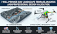
Get expert UAV landscape terrain analysis, professional design validation, and FAA compliance. I specialize in BVLOS mission planning, site-specific terrain mapping, and aerospace engineering review.
Are you preparing for a commercial drone operation in the USA? In 2026, airframe safety and site-specific landscape data are mandatory for professional insurance and flight waivers. I provide high-precision engineering audits to ensure your UAV or VTOL project is structurally sound and environmentally optimized for its mission area.
What this service includes:
Secure your project with data-backed validation. Contact me to verify your mission today!
Please inform the freelancer of any preferences or concerns regarding the use of AI tools in the completion and/or delivery of your order.
Senior Aircraft Engineer MATLAB Simulink Modeling and Aerospace Design
Languages
Does your analysis cover FAA Part 108 BVLOS requirements?
Yes. My landscape analysis and mission planning are designed to support the technical documentation required for BVLOS (Beyond Visual Line of Sight) waivers, focusing on terrain clearance and safety buffers.
What is included in the "Design Validation" report?
I perform a professional engineering review of your aircraft's specifications, structural limits, and flight controller logic to ensure the design is capable of the intended mission in your specific landscape.
Can you provide coordinates for autonomous mission software?
Absolutely. I can export terrain data and mission waypoints in formats compatible with QGroundControl, Mission Planner, or custom enterprise ground stations for immediate deployment.
