Browse categories
Explore
Fiverr Pro
English
$
USD

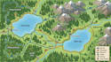
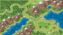
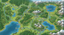
I specialize in designing professional bike trail maps, cycling maps, hiking route maps, walking trail maps, and outdoor recreation maps. Whether you have a GPX file, KML file, route coordinates, existing map, sketch, or project reference, I can transform your information into a clear and visually engaging map.
SERVICES I OFFER
WHY CHOOSE ME
I work with cycling tour companies, bike clubs, hiking organizations, adventure tour operators, tourism businesses, outdoor recreation companies, parks, resorts, campgrounds, event organizers, and travel businesses. Contact Me.
Please inform the freelancer of any preferences or concerns regarding the use of AI tools in the completion and/or delivery of your order.
Map Designer
Languages
What information do you need to create my map?
Please provide your GPX file, KML file, route coordinates, existing map, route description, sketch, or other available reference materials.
Can you create a map from a GPX file?
Yes. I can use your client provided GPX route information as a reference for designing and visualizing your route map.
Can you create maps with multiple cycling or hiking routes?
Yes. I can create maps showing multiple routes, trail networks, route connections, and points of interest.
Can you include landmarks and facilities?
Yes. I can include landmarks, attractions, parking areas, rest locations, entrances, checkpoints, and other locations you provide.
Can you redesign an existing trail map?
Yes. I can redesign an existing map to improve its visual appearance, organization, readability, and overall presentation.


