I will build 3d web gis systems using cesium, potree
J
J
Johnvhel A
5.0
5.0
Full Screen
Full Screen
Full Screen
About this gig
My Services:
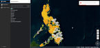
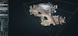
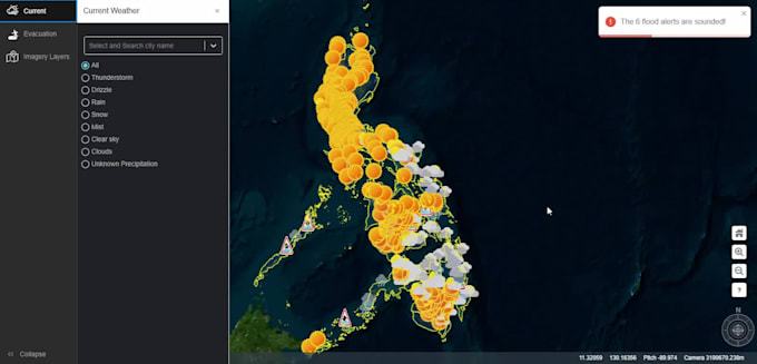
Visualization of spatial data: Points, polylines, polygons, 3D models, 3D tiles, terrains, aerial imagery, or satellite images.
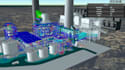
Underground spatial data visualization: Seamlessly display and analyze data below the surface.
Creation of spatial elements: Drawing polygons, polylines, and points with precision.
Measurement tools: Implementing features like area and length calculations.
Custom camera controls: For example, First-Person View (FPV) or other tailored camera functionalities.
Spatial analysis tools: Including advanced features like viewshed analysis or terrain cut volume calculations.
Development of editors: Custom tools such as 3D tile location editors or annotation editors.
Custom plugins (Mixins): Tailored solutions to extend functionality.
3D surround video and billboard video integration: Enhance your projects with immersive video experiences.
Custom 3D geometry development: Unique 3D models tailored to your needs.
Custom server development: Stream your spatial data (terrain, image tiles, etc.)
Integration with popular frameworks: Seamlessly connect CesiumJS apps with WordPress, Laravel, WebPack, React, Vue, or Angular.
Website type
Business
Programming language
JavaScript
PHP
C#
React
Angular
Website features
Marketing
Forum
Social media
Customer support
Inventory
Analytics
Chat
Map
Dashboard
Reviews
Respect third-party rights
Please be aware that it is against Fiverr's policies for sellers to include themes, templates, or any other elements that infringe third-party rights or applicable laws in the delivered work. Read more about in our Guide to Responsible Digital Creation.
Get to know Johnvhel A
Johnvhel A
5.0(1)
FromPhilippines
Member sinceSep 2014
Last delivery1 year
Languages
English
Hello
With over 8 years of experience in the world of GIS, I'm your go-to expert for transforming satellite imagery into captivating maps. Using tools like Potree, CesiumGIS, and ArcGIS, I bring the earth to life—one pixel at a time. 🗺️✨
💼 Tech Wizardry: My coding skills in JavaScript, PHP, C#, and C++/C make complex geospatial challenges look easy.
🛰️ Satellite Whisperer: From remote sensing to satellite image processing, I have a knack for extracting valuable insights from the skies.
Let's connect and craft the next big GIS adventure together! 🌟
Reach out, and let’s map the world! 🌐🚀